
Introduction
In November 2025 the owners of the project submitted an application to Ballina Shire Council to develop Stage 1.
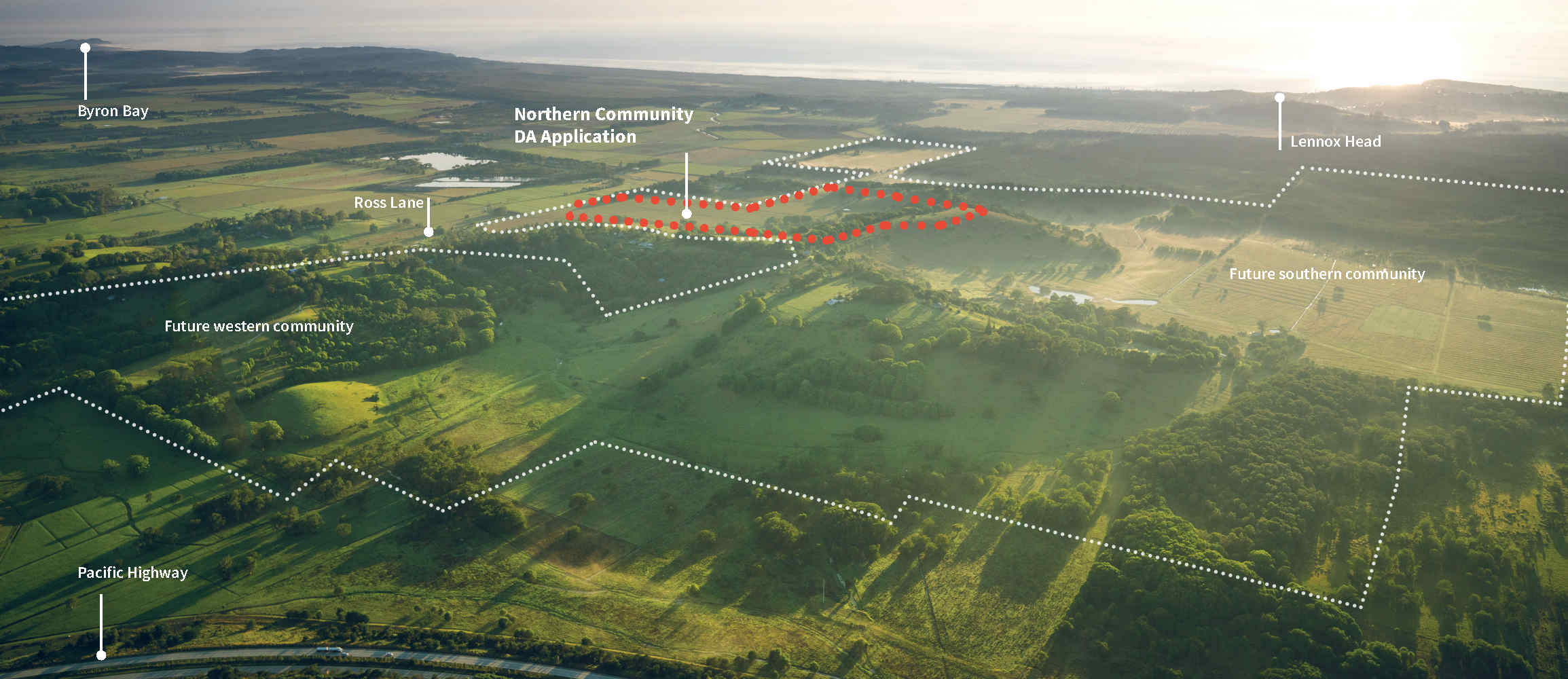
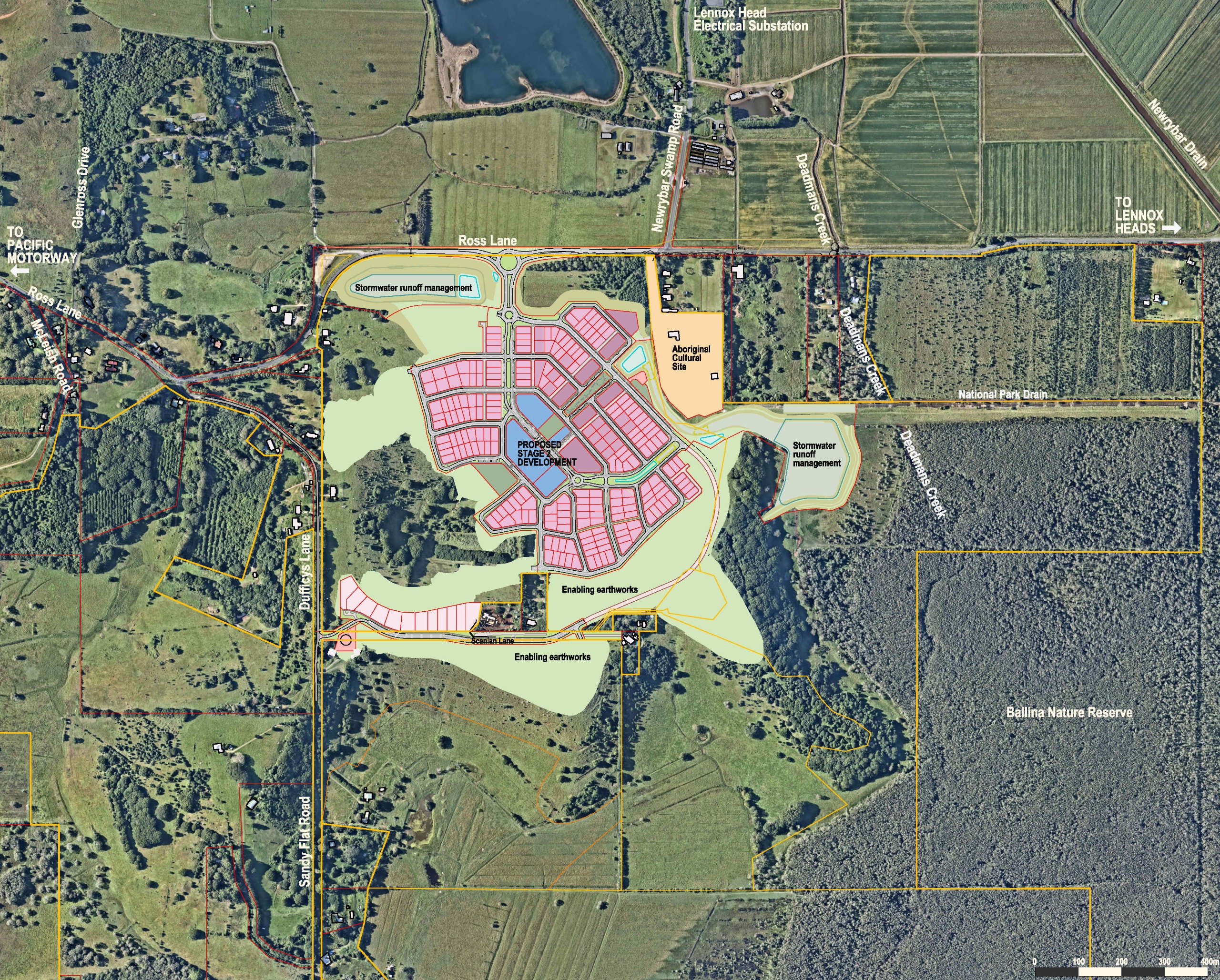
Stage 1 covers development in the northern neighbourhood incorporating principles from the previously released masterplan to deliver a self-sustaining community of about 300 dwellings or 247 lots.
Stage 1 will also feature a small retail and commercial area, and an interconnected network of parks, pathways and cycleways. It encompasses an area of approximately 69 hectares with a two to three year construction period.
Enabling earthworks will be an important part of this stage - works will establish the infrastructure framework for the future stages while managing and environmental impacts and mitigating flooding. As such, Stage 1 will feature new drainage basins, roads, parks, and civil infrastructure.
For an overview of Stage 1 and all key project parameters please see our Statement of Environmental Effects.
Major development application reports
A full range of reports and plans have been submitted for review and public comment as part of the development application for Stage 1.
The reports include:
Planning & Engagement
- Urban design report
- Community engagement report
- Voluntary Planning Agreement (for delivery of infrastructure)
- A Statement of Environmental Effects
- Biodiversity Development Assessment Report
- Aboriginal Cultural Heritage Management Plan
- Civil engineering design and documentation
- Bulk earthworks plan
- Erosion and sediment control plans
- Road construction plans
- Bushfire assessment report
- Development cost report
- Stormwater monitoring plan
- Pest management plan
- Mosquito risk and management
Environmental & Heritage
- Statement of Environmental Effects
- Biodiversity Development Assessment Report
- Aboriginal Cultural Heritage Report and Aboriginal Cultural Heritage Management Plan
Impact assessments
- Flood impact assessments
- Geotechnical Assessments
- Landscape visual impact assessment
- Land Use Conflict Risk Assessment
- Air quality impact assessment
- Ground water modelling and impact assessment
- Traffic engineering report
- Noise and vibration impact assessment
- Heritage impact assessment
- Acid Sulfate Soil Management Plan
Infrastructure
- Water and sewer servicing
- Electricity connection report
Construction
- Civil engineering design and documentation
- Bulk earthworks plan
- Erosion and sediment control plans
- Road construction plans
- Bushfire assessment report
- Development cost report
- Stormwater monitoring plan
- Pest management plan
Monitoring and management
- Stormwater monitoring plan
- Pest management plan
- Mosquito risk and management
Flooding
It is recognised that surface water and flood management is a critical issue for any development in the area.
Initial assessments for the area for the August 2024 amendments to the Development Control Plan showed no impact on regional flooding if the area were developed.
Additional modelling has now been completed as part of the development application for Stage 1.This includes use of an updated regional flood model that has recently been adopted by Ballina Shire Council.
The updated flood impact report for Stage 1 also includes any impacts for both the development and any future Ross Lane upgrades being considered by Council.
In summary the updated (October 2025) flood report finds:
- For all modelled events, increases in peak flood level only occur within the site boundary of Stage 1, with the greatest increases occurring within the two proposed detention basins. There are no significant increases occurring on external properties.
- There are some minor benefits to the north of the site in the form of reduced peak flood levels.
- There are some minor localised decreases in peak velocity near Ross Lane and some minor increases adjacent to the embankments of the main detention basin proposed for Stage 1.
Traffic
As part of Stage 1 there is a new double-laned roundabout proposed at Ross Lane and the entry into the new northern neighbourhood.
It is anticipated that once developed the northern part of the development will utilise the proposed Ross Lane/New Road Roundabout while the southern part of the development (containing 12 residential dwellings) will utilise existing Ross Lane/Dufficys Lane intersection.
An assessment of current and future traffic (10-year horizon) shows that:
- The Ross Lane/New Road roundabout will perform well during AM and PM peaks along with the Ross Lane / Dufficys Lane intersection.
- The Ross Lane/New Road Roundabout will perform well during the entire Stage 1 development.
- The proposed development will not have a significant impact on the future surrounding road network.
- The proposed internal Stage 1 road network is suitable for the scale of development.
Biodiversity
The project has been designed in accordance with the Biodiversity Conservation Act to follow ‘avoid and minimise principles’ by excluding proposed clearing in mapped wetland areas and aligning the proposed footprint within areas of ecologically low quality and historically cleared land that continues to be used for agricultural land uses.
Overall, the impacts to biodiversity are predicted to be minimal.
Where possible, native trees will be retained along Dufficys Lane and the boundary of the proposed earthworks, to further minimise the impacts of vegetation clearing.
Of the area impacted, 4.5 hectares of impacted vegetation has been classed as requiring some level of offset by the project. No ‘Areas of Outstanding Biodiversity Values’ overlay the project area.
Effective mitigation measures, ongoing management and monitoring will reduce the risk of indirect impacts to the surrounding habitat, including the Ballina Nature Reserve to the east.
In total, 34 hectares of land within Stage 1 will be rehabilitated with a mixture of lowland rainforest and swamp oak floodplain forest as part of the offset arrangement for the project.
Visual impact
The visual impact for the Stage 1 development has been assessed as negligible for the sub-regional visual impact (distances greater than 2km), taking in consideration the limited size of the housing within the current surrounding landscape.
Cultural Heritage
As part of past and current cultural heritage assessment and consultations for the project area, a site of high archaeological significance has been identified. This area, to the north-east of Stage 1, will be excised as a separate parcel for the primary purpose of Aboriginal cultural heritage protection. The site will be secured as a no-harm / no-go area, identified on all construction and subdivision plans. Ownership is ultimately intended to be transferred to a Registered Aboriginal Party controlled body.
Earthworks and Construction
Bulk earthworks scheduled for approximately the first twelve to eighteen months at the site. Excavation will begin along the site’s ridgelines, with the extracted material transported and stockpiled in low-lying areas for preloading (a process designed to compact soft sediments).
Following the completion of bulk earthworks, construction activities will transition to the installation of underground services, road construction, and final site shaping in accordance with the approved design. This phase is expected to take an additional twelve to twenty-four months to complete.
Monitoring
A range of monitoring and reporting requirements will accompany this project. Reports have been prepared which assess and make recommendations on air quality, noise and vibration, stormwater, cultural heritage, environmental and construction matters.
Next steps
Ballina Shire Council is exhibiting the development application for Stage 1 for public comments until 12 December 2025.


